
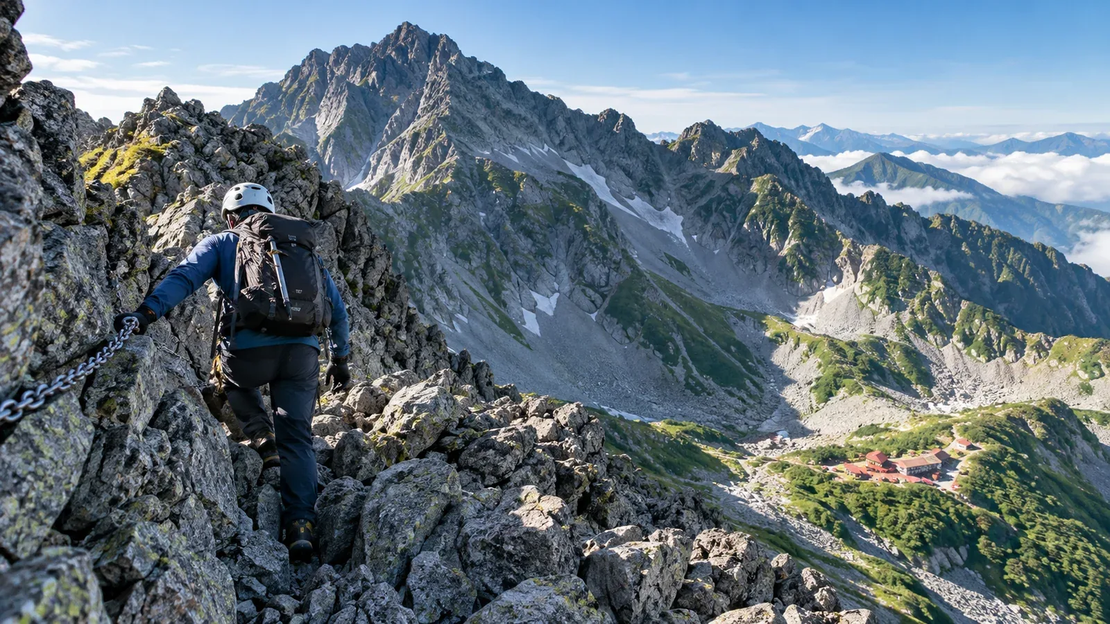
From Kamikochi, go through the Karasawa cirque to Mount Okuhotaka (3,190 m). Hotakadake Sansō suggests this common out-and-back for a first climb in the Hotaka range. Above Karasawa, the route has rocky ridges, chains and ladders. Weather and footing can make a big difference.
If you’re planning your first climb from Karasawa, use this guide to assess your experience and plan the stages, gear and turnaround points. Check official sites for hut prices and opening dates, trail conditions and transport to Kamikochi.
What experience the route calls for
Mount Okuhotaka shares third place among Japan’s highest mountains with Mount Aino. From Karasawa, climb the rocky Seitengrat to Hotakadake Sansō at the Shiradashi Col. From the hut, steep ladders, chains and rock lead toward the summit. You’ll need to know how to choose secure footholds, shift your weight and avoid dislodging stones.
If you have done overnight hikes or walked easier trails in the Alps, you may still need practice. Ask yourself whether you can do the following.
- Climb and descend steadily on rock with chains and ladders. Practise on similar terrain and check that you can stay composed when tired.
- Notice changes in how you feel at altitude and change the plan. Even if you felt fine before, pay attention to how you feel on this trip.
- Find your position using a topographic map, compass and hiking map app. Save the app’s map for offline use.
- Pack what you need for rock and an overnight stay, including a headlamp, rain gear and warm clothing.
If you need more practice, choose a shorter rocky route with an easy way out or consult a guide whose certification covers your route and season.
Planning days and walking times
Hotakadake Sansō lists about 9 hours of walking from Kamikochi via Yokoo and Karasawa to the hut, and about 7 hours 20 minutes back. Both estimates exclude breaks and the summit round trip. Allow extra time for Mount Okuhotaka itself, queues at ladders, breaks and delays on the descent.
In a three-day plan, walk from Kamikochi to Karasawa on day one, climb the summit and return to Karasawa on day two, then walk out to Kamikochi on day three. If you stay at Hotakadake Sansō on day two, account for the long final descent and the last bus. Consider a spare day and decide when to shorten the trip because of weather or fatigue.
Start early on days with exposed terrain. Check Japan Meteorological Agency forecasts and alerts, and forecasts for wind and lightning in the area, the day before and the morning of the trip. If thunderstorms are forecast, reconsider the start or summit even early in the day. If you hear thunder or see lightning, leave the summit or ridge and seek shelter inside a building as soon as possible.
Crossing the Seitengrat from Karasawa
The route out of the Karasawa cirque climbs the Seitengrat. Here’s what to check along the way.
Find the start of the ridge. Ask the Karasawa huts about current trail conditions. Use your map, signs and markers to find where the Seitengrat starts. If there’s a queue, wait on stable ground and keep checking the route yourself.
Move carefully on rock. Keep three stable points of contact while moving the fourth. Test a foothold before putting your weight on it. Turn around if wet rock or ice makes it unsafe to continue.
Ladders and chains directly above Hotakadake Sansō. The hut warns that accidents are frequent near the ladders just above it. Keep your distance and look for footholds you can use on the descent as well. If crowds, wind or fatigue make you unsure about descending, you can turn back at the hut.
Altitude, weather and turning back
Altitude illness. A night at Karasawa, at roughly 2,300 m, breaks up the climb from Kamikochi. People react differently to altitude. If you develop a headache or nausea that could indicate altitude sickness, stop ascending. Descend if symptoms worsen. If there are severe symptoms such as breathlessness at rest or stumbling, call for rescue immediately and descend as quickly as you safely can.
Changing weather. Wind and rain can chill you even in summer. Keep your rain jacket and trousers, warm layer and gloves within reach. Put them on before you get cold and wet. Check conditions again before stepping onto the ridge and decide whether to continue.
When to turn back. Put the start of the Seitengrat and Hotakadake Sansō in your plan as places to reassess weather, how people feel and time remaining to descend. If you expect to run out of time or conditions to worsen, turn back early along the route you’ve checked.
Gear priorities for rocky ridges
In addition to your low-elevation day-hike kit, check the following items.
Footwear. Choose hiking footwear that fits well and grips on rock and scree. Try it on a short rocky trail with the load you’ll carry and check how securely you can place your feet.
Helmet. Wear a climbing helmet on the Seitengrat and the rocky section above the hut because of rockfall and falls. If renting, confirm where and when you can get one and whether it’s in stock.
Warm layer. Ridge winds can make it feel cold even in sunshine. Pack an insulating layer such as a fleece or insulated jacket for breaks and delays.
Water and trail food. Check opening dates and water availability at Karasawa and Hotakadake Sansō before relying on them to refill. Carry enough in case you can’t refill, and stop to eat or drink somewhere safe away from the rocky sections.
What to do next
Review your experience first. If you’re unsure about climbing and descending rock, consider a short practice route or a suitably qualified guide. When the plan is ready, check hut bookings, the trail, Kamikochi buses and how to file your hiking plan with Nagano. You can also exchange information with experienced hikers and potential companions in Nordwand’s Base Camps.
References
- Japan Meteorological Agency: weather alerts and lightning safety
- Japan Ministry of the Environment and official Kamikochi website: visitor rules and transport
- Nagano Prefecture: hiking plan filing and helmets
- Hotakadake Sansō and Karasawa huts: route, opening dates and water
References and sources
- Geospatial Information Authority of Japan | Elevation ranking of Mount Okuhotaka and Mount Aino
- Hotakadake Sansō | Karasawa and Seitengrat route guide
- Hotakadake Sansō | Trail conditions
- Hotakadake Sansō | Accommodation guide
- Karasawa Hütte | Route guide
- Karasawa Goya | Opening dates and local updates
- Official Kamikochi website | Transport and access
- Japan Ministry of the Environment | Chubusangaku National Park visitor guidelines
- Nagano Prefecture | Filing a hiking plan
- Nagano Prefecture | Areas where a climbing helmet is recommended
- Japan Meteorological Agency | Weather warnings and advisories
- Japan Meteorological Agency | Staying safe in lightning
- National Mountaineering Training Centre | Basic climbing movement
- CDC | Travel to high altitudes