
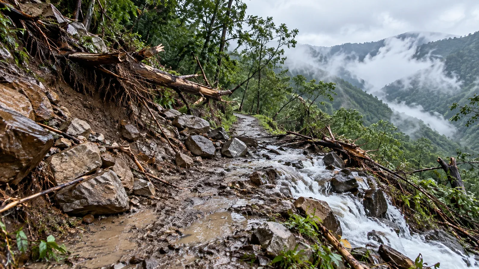
A typhoon can affect a hike well before its centre comes near, and the trail can stay hazardous after skies clear. Plan around both the weather and the condition of the route, including the roads and transport you will need to return.
Before the storm, check whether wind and rain could reach your route early. After the storm, check what has happened to slopes, stream crossings, bridges and access roads. A weather update and a trail report answer different questions.
Before the typhoon approaches: when can the mountains be affected?
Heavy rain and strong wind can affect an area even when the storm centre is far away or expected to remain offshore. Two effects matter especially on mountain routes.
Rain bands and fronts. Outer rain bands can bring bursts of heavy rain. Moist air from the storm can also feed a front well away from the centre. Rain falling upstream can raise a stream even if little rain is falling at the crossing.
Strong winds and gusts. Direction and strength vary with the track, the wider weather pattern and the terrain. Ridges, summits and ground above the treeline are exposed. Strong gusts can make it hard to keep your footing.
Use Japan Meteorological Agency (JMA) typhoon information, regional warnings and a mountain forecast for your route. A JMA forecast circle shows a 70% probability range for the centre at a specified time. Rain and wind can affect areas well outside the circle. Change the plan early if either could affect the hike or the way back.
After the typhoon passes: hazards that can outlast the storm
A bright morning can follow a typhoon. Check how much rain fell and what happened along the route before taking the improving weather as a reason to go.
Landslides and rockfall
Heavy rain can leave soil saturated and slopes unstable after rainfall stops. Rockfall and landslides can still occur, and how long the danger lasts varies with the site and rainfall. Check local advisories and closures, especially for routes below steep slopes or through gullies.
Washed-out trails, fallen trees and damaged bridges
Runoff can cut through a trail, and fallen trees and damaged bridges can block the route. Check the responsible municipality, park or trail manager, and ask a local mountain hut for recent observations when available. Confirm each affected section and check the access road before filing your hiking plan.
Streams running high
High or fast water can sweep people off their feet, and water can still be rising after rain stops. If a crossing is swollen or swift, turn back or use a verified alternative with a usable bridge. Keep away from damaged crossings.
How to decide when to go back
Assess the weather and the route separately. There is no set number of hours after a typhoon that makes every trail passable.
Weather for the entire trip. Check the latest regional forecast, warnings and mountain forecast through the expected return. A front or another low may follow. Heavy rain and strong wind can also continue after the typhoon is reclassified as another type of low.
Conditions on the route. Check recent notices for the exact trail, crossings and roads. If you cannot confirm a section with likely damage or flooding is usable, choose a different route or postpone.
- Look for current closure or reopening notices from the municipality, park office or trail manager.
- Ask a mountain hut about the affected stretch if it has recent observations. The hut’s operating status covers the hut itself.
- Use local police and mountain club reports as additional information and check when each was issued.
The presence of other hikers or the absence of a new notice cannot confirm a route is passable. If you find damage, high water or an official closure, turn back from a safe point.
Where to get information
Use each source for the question it can answer.
- Track, strength and expected wind and rain: JMA typhoon information, regional forecasts and warnings.
- Weather at your elevation: A mountain forecast for the hours you will be on the route.
- Trail and road damage: The municipality, park office or trail and road managers.
- Hut opening and nearby observations: The hut’s official notices or contact.
- Local safety information: Prefectural police and mountain clubs, with attention to publication dates and the routes covered.
Recheck the evening before and the morning of the trip. If information on a potentially damaged section is unclear, contact its manager or select a route with current access information.
Planning during typhoon season
JMA’s 1991–2020 averages show that typhoons form, approach Japan and make landfall most often from July through October. Check active storms whenever you plan to hike, including outside those months.
Build room to cancel or move the trip. Check transport and accommodation terms in advance and keep an alternative date or route. Confirm what happens to the return transport if services are suspended.
The track can change as a typhoon approaches. Keep checking its expected effects, then wait for route information before returning to a potentially affected mountain.
Put it into practice
Before booking your next trip, save the JMA typhoon page and contact details for the relevant trail and road managers. Check the cancellation terms and mark a no-crossing alternative or an alternative date. Nordwand’s partner directory can help you find participating huts, and the trail manager can confirm access to the route.
Sources
- Japan Meteorological Agency: typhoon forecasts, warnings and Kikikuru risk maps
- Japan Meteorological Agency: outer rain bands, fronts and long-term typhoon statistics
- Yamanashi Prefecture and Japan’s Ministry of the Environment: trail access and post-storm hazards
- US National Park Service and Japan National Police Agency: trail safety and mountain incident statistics
References and sources
- Japan Meteorological Agency: current typhoon information
- Japan Meteorological Agency: how typhoon information is presented
- Japan Meteorological Agency: typhoon winds and heavy rain
- Japan Meteorological Agency: typhoon formation, approaches, landfalls and tracks
- Japan Meteorological Agency: weather warnings and advisories
- Japan Meteorological Agency: Kikikuru risk maps
- Yamanashi Prefecture: mountain hiking information
- Japan Ministry of the Environment: example of a trail reopening with remaining hazards
- US National Park Service: trail safety and water crossings
- Japan National Police Agency: mountain incident statistics