
Geology of the Moneiga Quartz Diorite
In 2009, F. Bea and colleagues used uranium–lead dating on zircon crystals from the Moneiga quartz diorite in the Saint Catherine area. Their measurements gave an age of 844 ± 4 million years. Zircon can preserve traces of the time it crystallized. The team interpreted the measurement as the age of crystallization of the diorite.
In 2014, M. Eyal and colleagues noted that the diorite body cuts through younger volcanic rocks of the Rutig Formation north of Gebel Musa. They questioned whether the zircon age could date the intrusion. The magma must have entered those volcanic rocks after they formed. The age of zircon grains and the timing of the intrusion are two different questions.
The Summit Chapel of the Two Theodores
The summit chapel is dedicated to Theodore the General and Theodore the Recruit. It has whitewashed outer walls and a single nave under a barrel vault. Fyssas notes that its construction date is undocumented and that the form and building techniques suggest a medieval origin.
Fyssas also cites an account by Nectarios, Patriarch of Jerusalem, published in 1677. In the monastic tradition Nectarios records, Moses saw the Burning Bush from this hill while tending the flocks of his father-in-law Jethro.
The Camel Path and the Monastery Below
The old Camel Path passes between Gebel Munajah and Gebel Musa. Fyssas links its construction to Abbas Hilmi I’s building projects in the mid-nineteenth century. Low stone retaining walls and channels to carry rainwater mark its course. Saint Catherine’s Monastery in the valley below dates to the sixth century. UNESCO added the Saint Catherine Area, which includes the monastery and its surrounding landscape, to the World Heritage List in 2002.
Two Early Photographs of the Valley
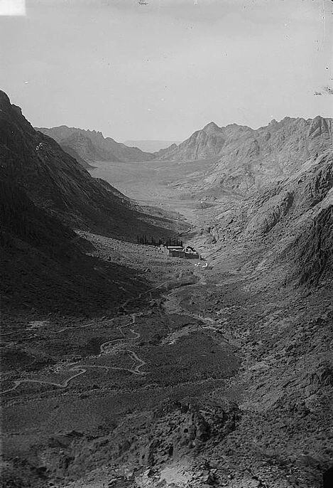
In 1868, James McDonald photographed Wadi el-Deir from the slopes of Gebel Munajah for the Ordnance Survey of the Sinai Peninsula. The British Library catalogs the view looking northwest past the monastery to the Plain of Er Rahah. The American Colony Photo Department later photographed the view northwest from the summit around 1900–1920. The orchard and the monastery’s fortified walls appear in the valley, with pale tracks crossing the foreground.
The Library of Congress preserves the two slightly different views of the valley on a single stereographic plate. This exhibition reproduces the right-hand image, which makes the line from the summit to the monastery easy to follow.