
Geological architecture: Pleistocene layers
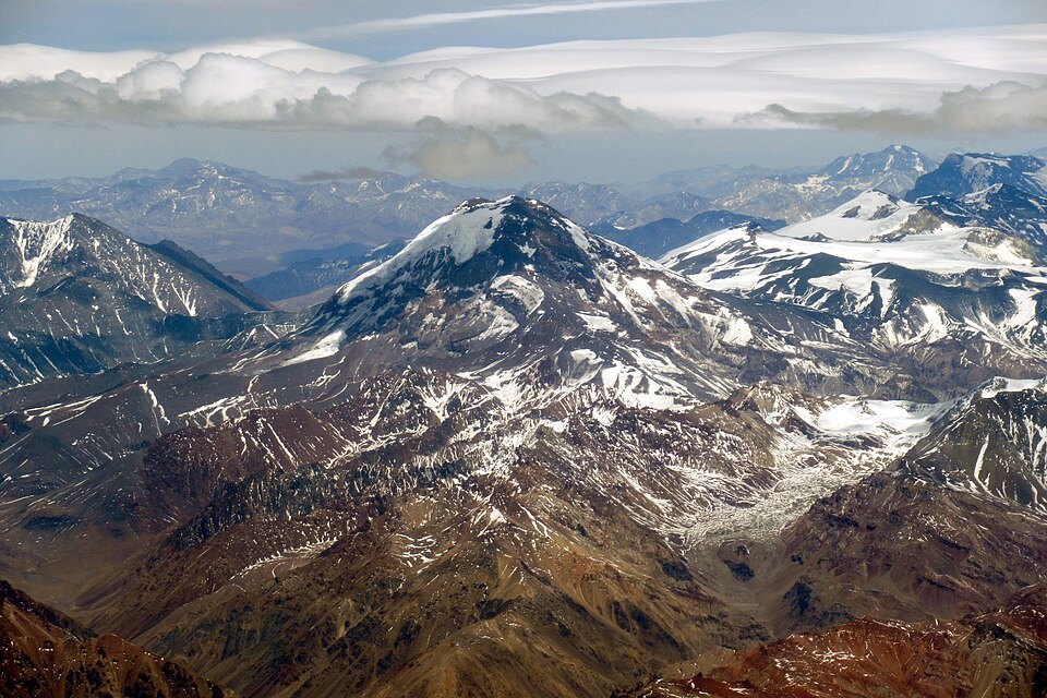
Geochronological research by Hildreth and collaborators — whose fieldwork dates from a 1984 expedition and was published in 2024 — reveals that the lower and middle slopes of the volcano consist of andesitic lavas from the lower and middle Pleistocene. Resting on this base is a dacitic dome in the southern sector of the summit, whose K-Ar dating yielded an age of 831 ± 116 ka, that is, just under one million years. The Smithsonian Institution's Global Volcanism Program describes the overall structure as a Pleistocene stratovolcano crowned by a complex of more recent lava domes, specifying that the summit does not represent a single flow but rather the final expression of prolonged and differentiated volcanism.
This stepped stratigraphy — basal andesites, apical dacites — has direct consequences for the morphology visible from both flanks. The slopes show variations in gradient and texture that reflect distinct eruptive episodes, while the dacitic dome imparts to the summit the rugged relief characteristic of viscous extrusions. The resulting edifice is therefore not the regular cone of a textbook volcano, but a complex accumulation whose interpretation requires careful distinction between the ages and compositions of each unit.
Mountaineering history: the first ascent of 1897
The summit of Tupungato was reached for the first time in the modern era in 1897, when Swiss guide Matthias Zurbriggen and British mountaineer Stuart Vines topped the mountain. The expedition was recorded in the documentation of the Sociedad Geográfica de Documentación Andina — Andeshandbook — as the founding milestone of mountaineering on this peak. Zurbriggen was by then one of the most experienced high-altitude mountaineers on the American continent, having participated in the first ascent of Aconcagua the previous year; the conquest of Tupungato expanded the cartographic and topographic knowledge of a border sector that was scarcely explored at the time.
The combination of altitude, glacial complexity, and relative isolation made Tupungato a demanding objective from the outset of its mountaineering history. The sources consulted focus the documented narrative on that 1897 milestone and on subsequent geological studies; any other episode in the history of ascents to the peak belongs to a record that falls outside the scope of this report.
Border geography: the boundary between Mendoza and the Metropolitan Region
Tupungato sits exactly on the international dividing line separating the Argentine province of Mendoza from the Metropolitan Region of Santiago, in Chile. This border position gives it a binational character reflected both in the administrative management of the territory and in the historical approaches to the massif. The elevation of 6,564 m is that recorded by the Argentine IGN; the slight discrepancy with values in other catalogues — which hover around 6,570 m — is common for peaks of this magnitude and stems from differences in surveying methods and geodetic datum used, without either figure being considered definitively incorrect.
Its location in the high central cordillera, between Aconcagua to the north and the volcanic Maipo node to the south, places Tupungato in one of the highest and meteorologically most severe sections of the Andes. The border in this sector follows not valleys or rivers but the watersheds of the summits themselves, so the natural, geological, and mountaineering history of the volcano belongs simultaneously to two countries whose scientific institutions — the Argentine IGN and the Chilean SERNAGEOMIN, which also catalogues the neighboring Tupungatito — have contributed to its documentation from complementary perspectives.
Tupungatito: an independent and active neighbor
Chile's SERNAGEOMIN classifies and monitors Tupungatito as a volcano separate from Tupungato, with its own eruptive history and an independent technical record. Although geographic proximity and nominal similarity cause frequent confusion, they are two distinct volcanic structures in both morphology and state of activity. Tupungato, the subject of this guide, has no recognized historical volcanic activity in the sources consulted and is described by the Smithsonian as a Pleistocene structure; Tupungatito, by contrast, has recorded eruptive episodes in historical times and receives continuous monitoring from Chilean volcanological authorities.
Keeping this distinction clear is essential for any scientific or mountaineering reading of the sector. Both summits form part of the same tectonic context — the subduction zone of the Nazca Plate beneath South America — but express different evolutionary stages of Andean volcanism: Tupungato represents a largely fossilized edifice whose main activity ceased hundreds of thousands of years ago, while Tupungatito illustrates the present-day vitality of that same regional magmatic system.