
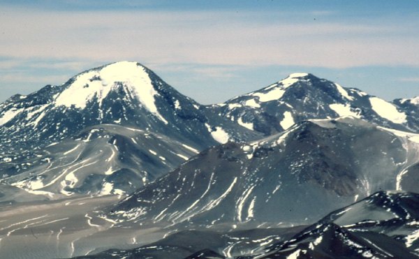
A Massif of Multiple Summits
The Complejo Volcánico Tres Cruces is not a single peak but a group of high points arranged from north to south along the border cordillera. The southern summit, Nevado Tres Cruces Sur, is clearly distinguished in expedition literature and is situated precisely on the border line between Chile and Argentina, at the meeting point of the Atacama and Catamarca provinces. The other summits of the group lie further north and have their own elevations and names, although confusion between them has been a constant in the technical literature. The one-metre difference between the cited values — 6,749 m from the IGN and 6,748 m from ascent accounts — reflects the complexity of measurements on high-altitude volcanic terrain before GPS became widespread.
The origin of the toponym Tres Cruces is not documented with certainty in the available sources. What is on record is that the name was also extended to the adjacent Chilean national park, the Parque Nacional Nevado de Tres Cruces, administered by CONAF, although the boundaries of that park do not necessarily encompass the summit of the massif. This distinction between the protected area and the volcanic massif itself is relevant to understanding the administrative geography of the region.
The First Documented Ascent and Subsequent Expeditions
According to the records of the Andeshandbook, the first documented ascent of Nevado Tres Cruces Sur took place in 1937, by a Polish expedition led by Witold Paryski. This milestone places the mountain within the cycle of Andean explorations of the interwar period, when European groups — Poles and Germans in particular — set their sights on the great heights of the arid Andes, many of them with no prior record of ascent. The name of Paryski, later also celebrated in the Tatras, is thus associated with one of the first documented passages through this sector of the Andean border.
Decades later, the American Alpine Journal published in its 1996 edition a detailed expedition account that distinguishes the southern summit precisely from the other points of the complex. This kind of technical documentation was crucial in establishing the topographic identity of Nevado Tres Cruces Sur against the ambiguity surrounding the other summits of the group. The ascents recorded during that period consolidated the approach routes from the Atacama altiplano and established the southern summit as the reference objective of the massif.
The Landscape of the Parque Nacional Nevado de Tres Cruces
At the foot of the massif, in Chilean territory, CONAF administers the Parque Nacional Nevado de Tres Cruces, a large protected area that forms part of the desert landscape of the Atacama region. The park is structured around two distinct lake sectors: Laguna Santa Rosa and Laguna Negro Francisco, high-altitude bodies of water that contrast with the prevailing aridity of the surroundings. These lagoons constitute distinct ecosystems within one of the driest deserts on the planet, and their inclusion in the park responds to conservation criteria different from those governing the management of the volcanic massif.
The park's proximity to the volcanic complex has generated some nominal confusion, but the geographic identity of the two is independent: the park takes its name from the mountain, not the other way around, and its official boundaries do not imply that the summit falls within the protected area. This clarification is especially pertinent in a territory where the scale of distances and the uniformity of the desert landscape can lead to the conflation of administrative and orographic realities that, in precise cartography, remain separate.
Position within the Arid Andes
At 6,749 metres according to the IGN Argentina, the Complejo Volcánico Tres Cruces ranks among the giants of the central Andes, a range that concentrates the highest density of six-thousanders on the planet outside the Himalaya and the Karakoram. Its location on the arid diagonal linking the Atacama desert with the Catamarca puna confers extreme climatic conditions: minimal precipitation, below-zero temperatures for much of the year, and exceptional ultraviolet radiation owing to the altitude and subtropical latitude. These characteristics have shaped both ascent strategies and the scarcity of historical documentation on the massif, whose land approaches cross areas of very sparse settlement on both sides of the border.
The available mountaineering literature, from Paryski's diary of 1937 to the accounts compiled in the American Alpine Journal of 1996, depicts a massif that has largely been tackled by expeditions with self-sufficient logistics, without permanent support infrastructure near the summit. This condition of relative isolation is consistent with the geography of the whole: Tres Cruces is neither an easy-access mountain nor one with established routes carrying the traffic density that characterises other, more southerly Andean six-thousanders, and its ascent record reflects that quality of frontier, in every sense of the word.