
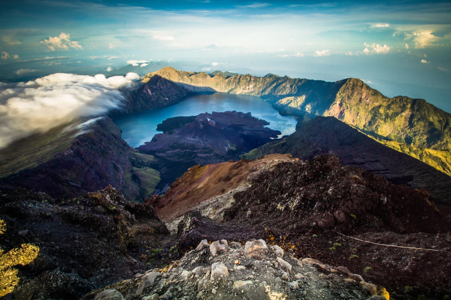
A Complex Landscape of Summit, Caldera, and Cone
The Rinjani volcanic complex is not a single landform but a layered assembly of distinct features whose formation spans different geological episodes. The modern Rinjani summit itself occupies the eastern side of the complex, where the Smithsonian Global Volcanism Program describes steep conical slopes visible from that direction. To the west lies a caldera measuring roughly six by eight and a half kilometres, a vast depression that now holds the lake called Segara Anak. Within the caldera, volcanic activity in more recent geological time built the younger Barujari cone, which rises from the caldera floor and has produced documented eruptions that sent lava flowing into the lake. These four elements — the Rinjani summit, the adjacent Samalas edifice, the lake, and Barujari — are related but geologically and historically distinct, and conflating them obscures a story that careful science has worked to separate.
Segara Anak, whose name UNESCO renders as meaning "Child of the Sea," occupies the caldera that was formed by collapse during one of the most powerful volcanic events of the past millennium. The lake sits within that inherited basin, while Barujari represents the volcano's continuing pulse — a younger cone built incrementally through subsequent activity within the same depression. The interplay of these features, along with pumice deposits, waterfalls, and coastal volcanic sediments that extend the geological story outward across the island, forms the backbone of the Rinjani-Lombok UNESCO Global Geopark, which received its designation in 2018.
The 1257 Samalas Eruption and Its Global Reach
The caldera's origin traces to an eruption in 1257 that ranks among the largest of the Common Era, and the scientific detective work behind that identification is itself a significant chapter in volcanology. Franck Lavigne and colleagues assembled evidence from multiple independent lines: local volcanic deposits, radiocarbon dates from material associated with the event, historical chronicles from the region, and the chemistry of volcanic glass preserved in deposits from Samalas — the edifice adjacent to the present-day Rinjani summit within the same complex. The decisive confirmation came from matching that glass chemistry against shards recovered from Arctic and Antarctic ice cores, where a large sulfate signal appears in layers dated to around 1258–1259, corroborating the 1257 eruption date.
Lavigne and colleagues' research is specific in attributing the 1257 eruption to Samalas rather than to the Rinjani summit itself, and in describing how the explosive eruption and subsequent collapse produced the caldera that Segara Anak now fills. The young Barujari cone visible within that caldera today is a product of later volcanic activity and should not be identified as the 1257 source. The ice-core sulfate record links the eruption to a global atmospheric disturbance of measurable scale, though claims of particular famines or societal collapses as direct consequences go beyond what the geological and geochemical evidence alone can establish.
Sasak Culture and the Mountain as Living Presence
The human landscape around Rinjani is as layered as its geology. The Sasak people are the predominant indigenous group of Lombok, and their villages, temples, and ceremonial practices form a continuous cultural heritage interwoven with the volcanic terrain. The geopark framework administered through Rinjani-Lombok MIDAS explicitly incorporates this human heritage alongside the geological narrative, treating pumice fields, waterfalls, and coastal volcanic sediments as parts of a single coherent story that connects the mountain's deep history to the communities living within its reach.
Among the traditions reported by the Indonesia Geological Agency is a Sasak belief in which a figure named Dewi Anjani — also called Rara Anjani — dwells in or holds sovereignty over the mountain. This is documented as a living tradition rather than a verifiable historical account, and it reflects the degree to which Rinjani functions in local culture not merely as a physical landmark but as a presence with spiritual identity. The geopark's recognition of this tradition alongside volcanic science and landscape heritage points to the breadth of significance the mountain holds: a geological record of global consequence, a visually commanding summit, and a named dwelling place of the sacred in Sasak cosmology.
Geopark Designation and the Rinjani-Lombok Framework
The Rinjani-Lombok UNESCO Global Geopark, designated in 2018, provides the institutional framework through which the complex's geological, natural, and cultural heritage is currently interpreted and managed. The geopark encompasses not only the volcanic summit and caldera but also the broader suite of features that record the eruption's aftermath across Lombok: pumice deposits that mark the reach of pyroclastic material, waterfalls cutting through volcanic stratigraphy, and coastal sediments that carry the eruption's signature to the island's shoreline. This landscape-scale perspective, promoted by the Rinjani-Lombok MIDAS organisation, positions the entire island as shaped by the same volcanic episode that produced the Segara Anak caldera.
The geopark designation reflects recognition that Rinjani's significance exceeds the summit itself. The Smithsonian Global Volcanism Program documents the complex under its own entry, acknowledging both the historical scale of the 1257 event and the continuing volcanic activity represented by Barujari. Together, the scientific record and the geopark framework present Rinjani not as a static monument but as an active system — geologically ongoing, culturally inhabited, and historically connected through ice cores and sulfate chemistry to a planetary atmospheric event more than seven centuries past.