
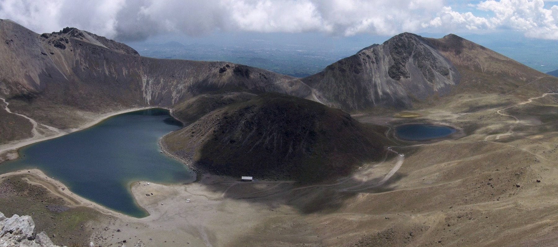
The crater's architecture and its named features
The summit crater of Nevado de Toluca measures approximately 1.5 km across and is open to the east, an asymmetry that the GVP attributes to the building's erosive and eruptive history. Inside lie Laguna del Sol and Laguna de la Luna, two bodies of water separated by El Ombligo, a rounded dacitic dome that forms the most distinctive morphological feature of the crater floor. Glacial erosion modified both the flanks of the volcano and the crater itself, leaving an imprint that overlays the original volcanic structures.
The volcano's dual name — Nevado de Toluca in the Hispanic tradition, Xinantécatl in the Nahuatl — reflects two historical layers of human relationship with the mountain. The term Xinantécatl remains in use in technical literature and on institutional signage, and its retention in CONANP documents underscores the official recognition of indigenous place names as part of the heritage associated with the protected area.
Eruptive history: the Toluca Upper Pumice
The GVP documents a major explosive event, radiocarbon-dated to approximately 10,500 uncalibrated years before present, that deposited the layer known as the Toluca Upper Pumice. This date is a radiometric estimate that must be understood with the uncertainty margins inherent in raw, uncalibrated dates and does not equate to a precise calendar date. The pumice deposit is one of the most important stratigraphic markers in the volcanic record of the Trans-Mexican Volcanic Belt at this latitude.
The range of materials documented by the GVP — andesites, dacites, lavas, and pyroclastic deposits — allows a long-term eruptive history to be reconstructed, one in which the most violent episodes preceded continuous human presence in the Toluca basin. No historical eruptions are known for this volcano according to the sources consulted, which distinguishes it from its neighbor Popocatépetl in terms of active volcanic risk.
From national park to protection area: nearly a century of legal status
Formal protection of Nevado de Toluca began in 1936, when it was decreed a national park; the following year, in 1937, a forest reserve was established within it. Over time and through changes in Mexican conservation policy, the category was changed to that of Flora and Fauna Protection Area (Área de Protección de Flora y Fauna, APFF), the designation under which CONANP currently administers it. This distinction between the original protection under a national park decree and the current APFF category is relevant to understanding the evolution of the legal framework governing the territory.
From a hydrological standpoint, the Archaeological Atlas and CONANP documents note that the slopes of Xinantécatl drain in two directions: toward the Toluca basin and toward the Balsas River basin. This position as a drainage divide gives the volcano a hydrological function that extends beyond the boundaries of the protected area, connecting its high-altitude glaciers and springs to water systems of regional importance.