
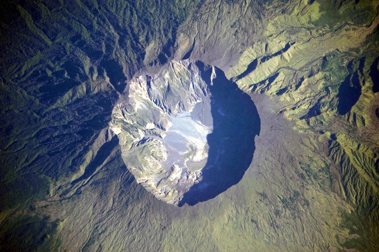
The Caldera and Its Formation
A caldera is not simply a large crater. It forms when a volcano's magma reservoir empties so rapidly during an eruption that the overlying structure loses its support and collapses inward, producing a depression far wider than any vent could excavate by blast alone. At Tambora the present caldera is the product of the climactic eruption of 10 April 1815, an event the Smithsonian Global Volcanism Program lists among the largest in historical records. Satellite imagery reveals the scale of the resulting depression — roughly six kilometres across — sitting at the summit of a mountain that still defines the outline of an entire peninsula.
The geological record at Tambora is therefore layered. The older collapse, dated to more than 43,000 years before the present, left its own signature in the island's stratigraphy before being overprinted by the edifice that grew toward 1815. What visitors and researchers encounter today is the product of both episodes, with the younger caldera floor now hosting the domes and flows that document the volcano's post-1815 activity.
The Eruption of April 1815
The climactic phase on 10 April 1815 generated pyroclastic currents — fast-moving mixtures of hot gas, ash, and fragmented rock — that travelled outward from the summit and reached the sea on all sides of the Sanggar Peninsula. Heavy tephra fall blanketed the surrounding landscape, destroying cropland across a wide area of Sumbawa. The human consequences were immediate and severe, extending across multiple causes and an extended period as communities were overwhelmed by both direct and downstream effects.
The physical transformation of the landscape was equally dramatic. A peninsula that had supported agriculture and settlement was left buried under volcanic deposits, its surface reshaped by the extensive 1815 fallout. On the caldera floor, domes and lava flows subsequently formed on a smaller scale, documenting that volcanic activity continued after the eruption in a more confined and reduced form.
Tambora and the Year Without a Summer
When a volcano of Tambora's magnitude erupts, it injects sulfur compounds high into the stratosphere, where they form aerosols that scatter and absorb incoming solar radiation over a broad area and an extended period. Local heavy tephra fallout and stratospheric aerosols are distinct processes with different geographic reaches and timescales. The stratospheric sulfate aerosols from Tambora contributed to measurable cooling across the Northern Hemisphere in 1816, a year documented in New England and parts of Europe for its severe summer frosts and failed harvests. NOAA's archived early American records, including sunspot observations and crop accounts, place those agricultural hardships in their original contemporary context.
The relationship between Tambora and the events of 1816 is real but requires care in the telling. Stratospheric aerosols alter global sunlight transmission without controlling every regional weather outcome; the cooling was geographically uneven, and other climatic factors were simultaneously at work. What the historical and scientific record establishes is a contributory link between the 1815 eruption and widespread 1816 temperature anomalies — not a single volcanic switch that turned off a year of summer across the entire world.
Tambora in the Geological and Historical Record
The Smithsonian Global Volcanism Program's documentation of Tambora distinguishes carefully between its two major collapse episodes, its historical eruptive products, and the subsequent smaller-scale activity that has built features on the caldera floor. This layered record makes Tambora an unusually well-documented case study in caldera-forming volcanism, where the gap between the ancient collapse and the 1815 event allows researchers to study both the long-term evolution of a large volcanic system and the immediate and downstream consequences of one of its most violent expressions.
The mountain also sits within the living geography of Sumbawa, an island whose communities have inhabited the flanks and surrounding lowlands across centuries that bracket the eruption. The 1815 event did not occur in an uninhabited wilderness; it transformed a populated peninsula, and the human dimension of that transformation — the immediate destruction, the displacement, and the longer disruption to food systems — forms an inseparable part of Tambora's historical identity alongside its geological record.