
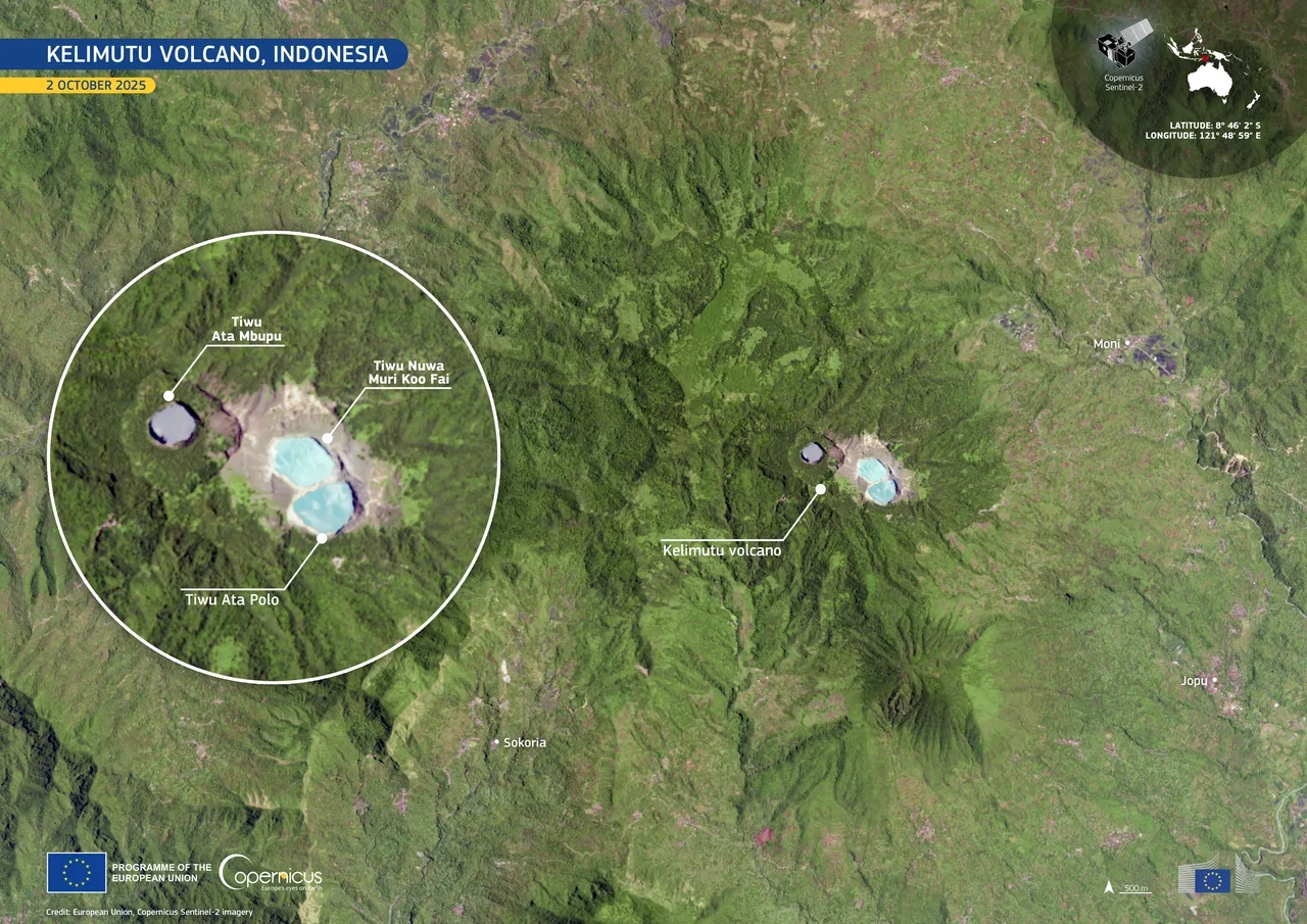
Three Lakes, Three Identities
The westernmost lake, known as Tiwu Ata Mbupu, sits apart from the other two. Immediately to the east, Tiwu Nua Muri Kooh Tai and Tiwu Ata Polo share a crater wall, making them neighbours in geology even as their waters can display strikingly different hues at the same moment.
Indonesia's Geological Agency has listed the three-lake complex as a geoheritage site, recognising the crater system not simply as a volcanic feature but as a time-varying landscape of scientific and cultural significance. The designation acknowledges that the lakes' identities are inseparable from their instability: the landscape that a visitor or researcher encounters is never precisely the landscape that existed before.
Hydrothermal Drivers of Colour Change
The colour variation in Kelimutu's lakes is not a surface phenomenon but a product of subsurface processes. According to the Smithsonian, the two eastern lakes — Tiwu Nua Muri Kooh Tai and Tiwu Ata Polo — are likely fed by underwater fumaroles, with hydrothermal upwelling introducing heat, gases, and dissolved minerals from depth. NASA's Earth Observatory documentation of the lakes emphasises that the oxidation state of the water column plays a central role in determining apparent colour, with shifts between reducing and oxidising conditions capable of transforming a lake's appearance across a wide spectrum. Because each lake has its own hydrothermal budget and mineral load, the three bodies of water respond to subsurface changes on independent timetables.
No single mineral accounts for the full range of colours observed across the lakes or even within a single lake over time. The interaction of sulphur compounds, iron oxides, and other hydrothermally introduced materials with changing pH and oxidation conditions produces a palette that can range across greens, blues, blacks, reds, and whites. A study published in the Indonesian Geological Journal examined the mechanisms behind these colour changes, documenting the chemical complexity that makes Kelimutu's lakes a continuing research subject rather than a system whose behaviour can be reduced to a simple formula.
A Documented Moment of Change
The dynamic nature of the lakes is not merely theoretical. The Smithsonian Global Volcanism Program records that on 3 June 2013, Crater II was observed with water that had shifted from blue toward light tan, while white emissions rose above the lake surface. Any characterisation of the lakes' colour is a snapshot tied to a specific moment rather than a stable property.
The 3 June 2013 observation recorded both the changed water colour in Crater II and white emissions above the surface. These dated, documented events form the empirical foundation on which geoheritage assessments and volcanological monitoring of Kelimutu are built.
Volcano Within a Volcanic Arc
Kelimutu sits within the Indonesian volcanic arc, the product of tectonic subduction that has generated a chain of active and dormant volcanoes across the archipelago. Its compound structure — the result of multiple eruptive episodes — means that its summit topography is more complex than a simple cone, with the crater system reflecting a long history of collapse, infilling, and renewed activity. The Smithsonian Global Volcanism Program catalogues Kelimutu as an active system, and the hydrothermal energy sustaining the crater lakes is a direct expression of the heat still present beneath the summit.
Flores itself is an island shaped by this volcanic history, and Kelimutu's position at 1,639 metres gives its crater lakes an elevation that has historically insulated them from direct comparison with lowland hydrothermal features. The combination of summit altitude, compound volcanic architecture, and three chemically independent crater lakes makes Kelimutu a distinctive node within both the Smithsonian's global volcanism database and Indonesia's national geoheritage framework — a volcano whose most scientifically compelling feature is not what it has erupted but what it continues to dissolve, oxidise, and transform in the water held within its craters.