
Topography and Neighbouring Summits
Topo50 sheet BZ11 connects Lucifer eastward to Nimbus Ridge and places the separate summit of Mt Bel — spelled with one l on the contemporary map — at 1,618 m to the south. The 1946 Grey River Argus article by Ralph Warburton used the spelling Bel; a 1954–55 Tararua Tramping Club trip log wrote Bell. The river below carries the official spelling Arawhata, though the form Arawata appears throughout period titles and reports.
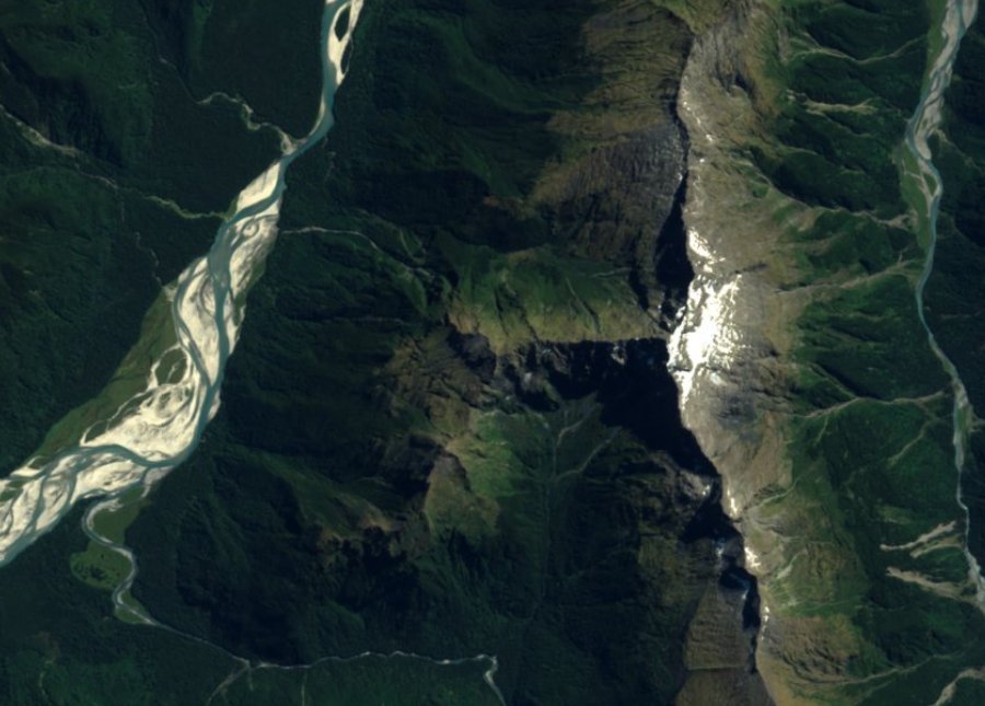
DOC describes the Arawhata as a long, wide braided river with both open and forested flats. The contrast between those wide gravel channels and the narrow rocky ridges above is visible in the 2016 satellite image, where the pale braided courses occupy the valley floor to the west while Lucifer occupies the central ridge above.
Geology at the Regional Scale
At the national 1:250,000 mapping scale, the summit falls within the Aspiring Lithologic Association of the Rakaia Terrane. GNS Science characterises the mapped unit as textural zone IV pelitic schist with conspicuous porphyroblasts, with subordinate psammitic greyschist and minor greenschist and metachert also reported for the unit. In plain terms, the principal mapped rock is metamorphosed mud-rich material, with some metamorphosed sand-rich rock alongside it.
The map assigns the geological unit a Triassic to Early Jurassic history. Its regional scale describes the bedrock beneath the summit and the wider area. The present ridges and valley reflect later uplift and erosion.
Survey Records and Early Observations
An 1885 Appendix to the Journals of the House of Representatives records a parliamentary survey that rough-traversed the Arawata and reached Williamson's Flat, mentioning Lucifer and Fingal's Head in the context of speculative mineral observations. The team recorded bearings and described the topography along the river and its tributaries. Charles Edward Douglas (1840–1916) produced a small pencil-and-watercolour landscape catalogued between 1870 and 1900, titled "Mount Lucifer — flats of Arawata," held at the Alexander Turnbull Library under reference E-058-019; it shows the mountain as seen from the valley flats.
Ralph Warburton, writing in the Grey River Argus on 6 April 1946, described seeing the rugged spurs and summits of Lucifer and Bel from broad flats farther up the valley. The Tararua Tramping Club's 1954–55 Olivines trip log independently names Lucifer, Bell, and Knob in the view at the end of the flats near Eros Creek, together with the Haast Virgins. Both accounts describe the peak as it appears from the valley floor, contributing a consistent visual record of its position and character from two separate parties nearly a decade apart.
National Park Context and Orbital Image
Mount Aspiring National Park was established in 1964. The park's management plan records the addition of the upper Arawhata and Dart valleys and the Wilkin and Wills catchments in 1970. Lucifer's inclusion within the present park boundary is verified from DOC public conservation land feature 10586 at the LINZ summit coordinates.
The header image is a north-up crop from the 2016 layer of the EOxCloudless satellite mosaic, which incorporates modified Copernicus Sentinel data from both 2016 and 2017. West is to the left, where the wide pale braided channels of the Arawhata are visible; Lucifer is the summit near the horizontal and vertical centre of the frame; the bright ridge to the right is a separate formation. The image is credited to EOX IT Services GmbH and reproduced under CC BY 4.0.