
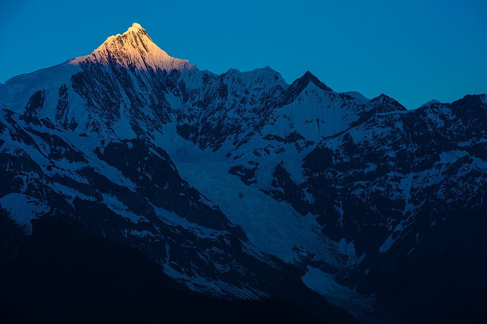
Topographic Form and Mountain Structure
Meili Snow Mountain, also known as Kawagebo, has its main peak rising high above the Yunnan–Tibet border, with the western slopes extending into Zuogong County, Tibet, and the eastern slopes facing the Lancang River valley in Deqin County, Yunnan. In this section of the Hengduan Mountains, the difference in relief is extreme; the vertical drop between valley floors and the main summit amounts to several thousand metres, producing a landform character defined by the abrupt transition from snowpeak to deep gorge. The American Alpine Journal's survey report on the Hengduan Mountains specifically describes this spatial arrangement of snowpeaks and gorges side by side, treating Meili Snow Mountain as a key reference for understanding the mountain structure of the entire Three Parallel Rivers region.
The Mingyong Glacier extends down from the southern face of Kawagebo Peak and is one of the lowest-latitude and lowest-elevation maritime monsoon glaciers in China. In geomorphological terms it forms a vertical corridor linking the high-plateau snowfields to the valley forests below. The zone where the glacier terminus meets the surrounding vegetation gives this 6,740-metre snowpeak a remarkably compact visual and geographic counterpoint with the low-elevation valley below.
The 1991 Disaster and the Mingyong Glacier Camp
Between 1990 and 1991, a Sino-Japanese joint mountaineering team attempted to climb the main peak of Kawagebo — the most thoroughly documented expedition ever mounted against this summit. According to the expedition record compiled after the event by team leader Hirai Kazumasa, the climbing party established a high-altitude camp on the upper Mingyong Glacier as an advance base for the summit push. In early 1991, an avalanche struck the camp area; all 17 members of the climbing team perished with no survivors. This event is known in mountaineering history as the "Meili Mountain Disaster" and is one of the deadliest accidents in the history of Chinese mountaineering.
After the disaster, portions of the victims' belongings and remains surfaced over subsequent years near the lower reaches of the glacier, providing material evidence of glacier movement. Hirai Kazumasa's record focuses on the geographical location of the camp and the condition of the mountain at the time of the avalanche; it draws no definitive conclusions about the specific cause of the accident. This former camp site and the glacier topography remain the most direct references for understanding the geographical context of the disaster.
The Tradition of Mountain Reverence and Local Understanding
Within the Tibetan folk belief system, Kawagebo is regarded as a fiercely protective mountain deity. Local government materials document the long-standing tradition of circumambulating the mountain maintained by Tibetan communities in the Deqin area. This practice of mountain reverence is not aimed at reaching the summit; rather, it expresses veneration for the sacred mountain by walking a circuit around it, with participants coming in an unbroken stream year after year. Local tradition regards the mountain itself as a sacred presence, and the 1991 disaster is widely understood locally as retribution for trespassing upon a sacred mountain — but this belongs to a framework of religious and cultural interpretation, distinct from geological or meteorological analytical explanations.
Kawagebo is also written as "Kawagebo" in Tibetan-derived Chinese transcription; Chinese-language materials sometimes use "Meili Snow Mountain" to refer to the entire massif and sometimes specifically to the main peak, with both usages coexisting in different contexts. UNESCO's inscription of the Three Parallel Rivers as a World Heritage Site was based on criteria relating to the region's natural geographic diversity, encompassing multiple mountain units including Meili Snow Mountain; this heritage status reflects regional natural values and not any endorsement of specific religious beliefs.