
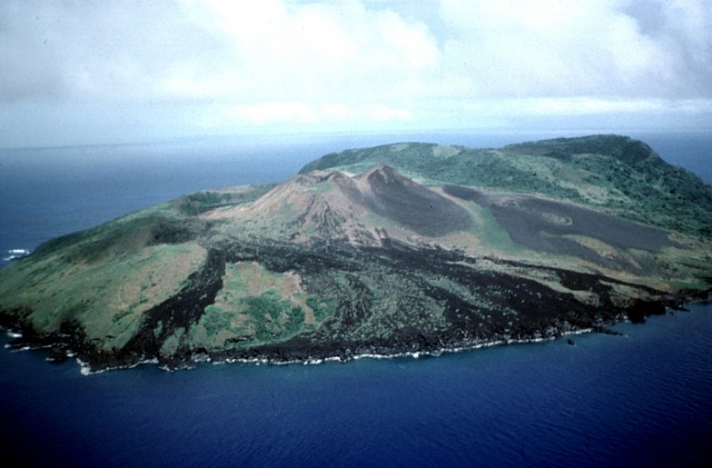
An Old Volcano and a Younger Cone
The U.S. Geological Survey identifies three features on Guguan: an eroded volcano in the south, a caldera containing a later cone, and the northern volcano. In Richard Moore’s 1992 aerial photograph, dark flows descend from the northern cone toward the shore. Behind it, vegetation covers much of the older southern terrain.
The University of Guam Marine Laboratory recorded the historical spelling Gugan in 1983. Its report gives the high point as 301 metres, the figure also used in the Chiba museum’s 1994 expedition report. The U.S. Geological Survey and the Smithsonian list 287 metres.
The 1882–1884 Eruption
The Smithsonian’s Global Volcanism Program dates the documented eruption to 1882–1884. It built the northern volcano and sent lava west and northwest to the sea. A 1983 University of Guam report describes intermittent steam at the northern cone in 1975.
Birds on the Forested Slopes
On 17 May 1992, members of a biological expedition led by the Natural History Museum and Institute, Chiba, landed on Guguan’s southwestern shore. Some climbed through forest to a ridge near the high point and recorded many nests in trees. The expedition worked with the Commonwealth’s natural resources department and the University of Guam Marine Laboratory.
In a 2016 survey by the Commonwealth’s Division of Fish and Wildlife, observers detected the Micronesian megapode (Megapodius laperouse) more often in forested areas than in open terrain. The Commonwealth lists Guguan as a wildlife conservation area.