
Terrain and Geology
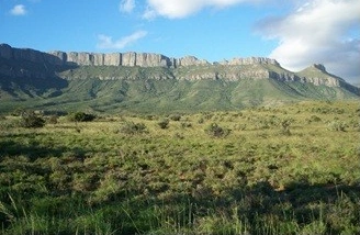
The range’s plateaus generally lie at 1,600–1,900 metres, with saddles between them and cliffs around their edges. Hard dolerite intrudes the shales and sandstones of the Beaufort Group. As the surrounding sedimentary rocks erode, the tougher dolerite helps retain the steep rims visible above the grass in Clark’s photograph.
Seen from the east, the ridge has a distinctive outline known as the Sleeping Giant. Clark and his colleagues trace the name to a 1987 national survey map.
Names and Early Documentation
In 1875 John Noble’s Descriptive Handbook of the Cape Colony referred to the Camdeboo and Sneeuwberg mountains in its chapter on the Graaff-Reinet district. The Library of Congress now indexes the names Camdeboo Berge and Kamdebooberge under Camdeboo Mountains.
Biodiversity Survey of January 2011
From 22 to 25 January 2011, ten biodiversity researchers visited the range. The team walked across the plateau to sample its plants, then looked more closely at seepages, rock outcrops and the edges of cliffs. Their 2012 report records that specimens were pressed and identified at the Selmar Schonland Herbarium (GRA).
Acmadenia kamdeboo and the Goewermentsberg Type
On 9 September 2008, Ralph Clark and O’Connor collected a shrub on Goewermentsberg. Its type specimen is held by the Selmar Schonland Herbarium as GRA0182785. In 2025 researchers compared the material and field photographs with related species. The South African Journal of Botany published the formal description of Acmadenia kamdeboo in its 2026 volume 188.
The 2026 paper records the shrub on rocky east- and southeast-facing plateau edges at elevations between 1,600 and 1,710 metres, typically on dolerite substrate and often rooted in rock crevices. The authors calculated an occupied area of approximately 8 square kilometres — a small fraction of the range's total extent. The collection date (September 2008), the survey that informed the broader context (January 2011), and the formal publication (2026) are three separate events in the plant's documentation.